France of the caricatures, puzzle map around 1850-60

France of the caricatures, puzzle map around 1850-60 France of the caricatures, puzzle map around 1850-60 France of the caricatures, puzzle map around 1850-60 France of the caricatures, puzzle map around 1850-60 France of the caricatures, puzzle map around 1850-60 France of the caricatures, puzzle map around 1850-60 France of the caricatures, puzzle map around 1850-60 France of the caricatures, puzzle map around 1850-60 France of the caricatures, puzzle map around 1850-60 France of the caricatures, puzzle map around 1850-60 France of the caricatures, puzzle map around 1850-60
France of the caricatures, puzzle map around 1850-60

France of the caricatures, puzzle map around 1850-60

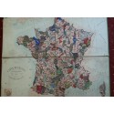
Rare puzzle board representing the France of the Second Empire with its 86 departments.
The departments are represented by grotesque faces topped with regional headdresses.

Carte de France instructive et amusante divisée en Quatre-vingt-six Départements.
Paris, G. Paulon

4 lithographed plates, glued on cardboard and bound with cloth

Tears, spots

53 x 67 cm

More informations about this item

France of the caricatures, puzzle map around 1850-60

France of the caricatures, puzzle map around 1850-60

Contact us by phone

Laetitia Georges : 06-87-46-25-57


Contact us by mail