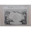
Ile de la Reunion, geographic map, 10 August 1852


Ile de la Reunion, geographic map, 10 August 1852
Map of Ile de la Reunion (formerly Bourbon Island) drawn in pen and ink (probably from a tracing ??) from the Atlas National Illustré drawn up by the French geographer Victor Levasseur and published around 1850
Paper, ink and watercolour
Signed and dated Caroline Ran 10 August 1852
Schoolgirl map ???
Condition : some stains and tears, the tape holding the paper and the mat has burnt the paper on the reverse just above the title
Framed and under glass
37,5 x 48 cm
with frame: 56 x 68,5 cm
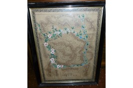
Paper, ink and watercolour
Signed and dated Caroline Ran 10 August 1852
Schoolgirl map ???
Condition : some stains and tears, the tape holding the paper and the mat has burnt the paper on the reverse just above the title
Framed and under glass
37,5 x 48 cm
with frame: 56 x 68,5 cm